Divide Ridge
Length: 3.6 miles
Beginning Elevation: 5,050 feet elevation.
End Elevation: 5,670 feet elevation.
Elevation Gain: 760 feet.
Trailhead: A fine day hike approach is from just west of Windy Point Day Use Area on US-12 (milepost 177). Take FR-1302 up, keeping right at 6.4 miles (at an informal campground), then left beyond this opening at 6.5 miles. Park at 9 miles in a pullout just west of a set of communication towers. Walk west and uphill along Divide Ridge along FR-1302, passing Hatton Road (FR-607) in 0.3 miles. [Long distance through-hikers will approach Divide Ridge from the upper terminus of the Hatton Road Hike (FR-7607)].
This trail segment offers a fantastic overview of the WO Douglas Trail setting in the southern Washington Cascades. The trail showcases much of the region’s dramatic and varied topography and geology. These landform features combine with an equally exciting array of ecological units as one ascends the trail, from upper shrub-steppe to dry conifer forest to subalpine, to encompass an impressive portion of the Ecosystems present along the entire WOD Trail. The diverse array of abiotic and biotic attributes makes the Divide Ridge segment a premier outdoor laboratory.
At Hatton Road, the Dry forest Interior Douglas-fir Ecosystem mantles the shady slopes, with prongs of wildflower-splotched shrub-steppe on the lithosols. A variety of colorful buckwheats enliven the lithosols and a good number of Columbian Biscuitroot cling to the rocky slopes, distinctive in early spring on account of their pinkish bloom and blue-green foliage, then again in summer when this foliage yellows. A few Bitterroot dapple the lithosols, too. Ascending to the head of a ravine and rounding a bend in the trail, the landscape quickly transitions into a denser forest of Douglas-fir, with many fine specimens of lime-green Western Larch. Dense currant thickets form the understory.
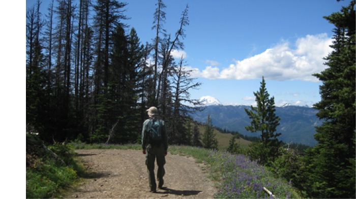
With each bend in the trail, depending on slope and aspect and climb in elevation, a new habitat type is encountered. Indeed, a bewildering array of vegetation types, from Great Basin shrub-steppe vegetation on exposed south and west slopes through several dry forest communities on the lower north slopes. Higher, the Subalpine Fir Ecosystem dominates north slopes, with scattered Mountain Hemlocks and Whitebark Pines, suggesting a very snowy regime. Finally, a fine grove of Engelmann spruce just shy of Jumpoff Lookout gives a “Rocky Mountain” flavor to the landscape, a vegetation type not known closer to the Cascade crest on the WOD Trail. The complex interplay of these dramatically different ecosystems provides niches for amazing biodiversity.
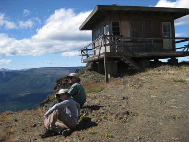
Jumpoff Lookout affords a commanding view of the region, indeed one of the finest anywhere in south-central Washington. To the east lies Yakima, nestled in the valley bottom in the Yakima Fold Belt. To the northeast beyond Yakima is Yakima Ridge and just left of that, Umtanum Ridge, both high ridges in the Yakima Fold Belt and within the Yakima Training Center, a military installation. Nearer at hand are the orchard communities of Cowiche and Tieton. To the north, Mt. Stuart, a huge granite outlier of the Cascades, pokes above Clemans Mountain, largest in the Yakima Fold Belt. The west side of Clemans Mountain reveals a large area of rumpled slopes. This is Sanford Pasture, site of huge landslides, including a very recent slope failure near The Nile, which forced rerouting of SR-410, the primary east-west highway in the valley. Just to the north of Jumpoff Lookout, down next to the Tieton River, is US Highway 12 which lies along the north shore of Rimrock Lake.
Geology
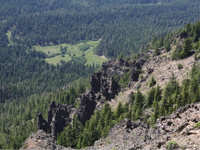
Dramatic basalt cliffs framing the Tieton River Canyon, westerly outliers of the Columbia Plateau basalts dominate the bedrock to the east. Geologists have mapped 12 units of the Grande Ronde Basalt in this canyon. Many outcrops of volcanic material from the Tieton volcano interfinger the plateau basalts. Scanning westward, the east side of Bethel Ridge looms; note communication towers atop the ridge, here at the western edge of the Columbia Plateau basalts. The multi-colored west side of Bethel Ridge is composed of thick outcrops of volcanic material erupted from the Mt. Aix caldera to the north. To the northwest, Shellrock Peak pokes above Bethel Ridge’s multi-hued volcanics. On the western horizon lies Mt. Rainier, Washington’s highest peak and monarch of the Cascade Mountains, with Rimrock Lake shimmering below. This reservoir was created for irrigation of Yakima Valley cropland. Surrounding this water body, are outcrops of the “Rimrock outlier,” the only significant chunk of “old rock” in the south Washington Cascades. These enigmatic metamorphic rocks, consisting of several named formations, had their origin perhaps faraway and were “docked” or accreted to growing North America in the distant past. East of Rimrock Lake are two imposing basalt oucrops, Goose Egg Mountain and Kloochman Rock, disjunct chunks of the Columbia Plateau. Kloochman Rock figures prominently in W. O. Douglas’ writings, and he hiked and climbed there a number of times. To the southwest the snowy Goat Rocks, a thoroughly eroded mega-volcano, beckon. One of the world’s longest andesite flows, emanates from this old volcano and snakes its way down the Tieton River just out of view below you, ending at Painted Rocks on the outskirts of Yakima. Off to the south Mt. Adams, another mega-volcano and Washington’s second highest peak.
The rocks at the lookout proper, with their buckwheats and penstemons, are alive on warm summer days with many butterflies. For some species of butterflies, mountaintops are favored sites to find mates.
To continue west on the WOD Trail, see the Jumpoff Meadows Hike or return the way you came.
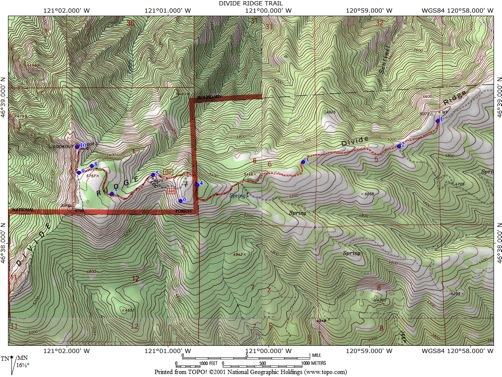
DIVIDE RIDGE TRAIL WAYPOINTS
1 - 46⁰38.841’ 120⁰58.331’ 4997’ Trailhead
2 - 46⁰38.668’ 120⁰58.715’ 5038’ Hatton Road Junction
3 - 46⁰38.560’ 120⁰59.665’ 5320’ Interior Douglas Fir Forest
4 - 46⁰38.406’ 121⁰00.717’ 5653’ Old Burn In Subalpine Fir Forest
5 - 46⁰38.474’ 121⁰01.154’ 5568’ Mountain Hemlock On North Slope
6 - 46⁰38.295’ 121⁰00.880’ 5632’ "Lupine" Bald
7 - 46⁰38.345’ 121⁰01.562’ 5662’ Subalpine Fir-mature
8 - 46⁰38.534’ 121,01.762’ 5644’ Engelmann Spruce-grove
9 - 46⁰38.487’ 121,01.887’ 5644’ FR-1302-West End
10 - 46⁰38.664‘ 121⁰01.906’ 5643’ Jumpoff Lookout